
Searching for trips..
Remote Weddell Sea Explorer incl. South Georgia
view cabin photo
view cabin photo
view cabin photo
view cabin photo
view cabin photo
view cabin photo
view cabin photo
view cabin photo
view cabin photo
view cabin photo
view cabin photo
view cabin photo
Remote Weddell Sea Explorer incl. South Georgia itinerary:
Your voyage begins where the world drops off. Ushuaia, Argentina, reputed to be the southernmost city on the planet, is located on the far southern tip of South America. Starting in the afternoon, you embark from this small resort town on Tierra del Fuego, nicknamed “The End of the World,” and sail the mountain-fringed Beagle Channel for the remainder of the evening. Enroute to South Georgia, you now cross the Antarctic Convergence. The temperature cools considerably within the space of a few hours, and nutritious water rises to the surface of the sea due to colliding water columns. This phenomenon attracts a multitude of seabirds near the ship, including several species of albatross, shearwaters, petrels, prions, and skuas.
Entering the South Georgia Maritime Zone, one of the largest protected waters in the world, we sail past the Shag Rocks. These impressive rocks lay 240km (150 miles) west of South Georgia and are home to several thousand South Georgia shags. The area around the rocks is known for its abundance of larger marine mammals, which feed on this comparatively shallow area of the South Georgia Ridge. After reaching South Georgia, you will have the chance to visit some of the following sites: Prion Island – This location is closed during the early part of the wandering albatross breeding season (November 20 – January 7). From January on, the breeding adults have found their partners and are sitting on eggs or nursing their chicks. Enjoy witnessing the gentle nature of these animals, which possess the largest wingspan of any birds in the world. Fortuna Bay – A beautiful outwash plain from Fortuna Glacier is home to a large number of king penguins and seals. Here you may also have the chance to follow the final leg of Shackleton’s route to the abandoned whaling village of Stromness. This path cuts across the mountain pass beyond Shackleton’s Waterfall, and as the terrain is partly swampy, be prepared to cross a few small streams. Salisbury Plain, St. Andrews Bay, Gold Harbour – These sites not only house the three largest king penguin colonies in South Georgia, they’re also three of the world’s largest breeding beaches for Antarctic fur seals. Literarily millions breed on South Georgia during December and January. By February the young fur seals are curious and playful and fill the surf with life and fun and large elephant seals come to the beaches to moult. Grytviken – In this abandoned whaling station, king penguins walk the streets and elephant seals lie around like they own the place – because they basically do. Here you might be able to see the South Georgia Museum as well as Shackleton’s grave. In the afternoon of day 6 and depending on the conditions, we will start sailing southwards in the direction of the South Sandwich Islands.
Like Shackleton in December 1914 on the Imperial Trans-Antarctic Expedition, also known as the Endurance Expedition, we leave South Georgia and aim for the South Sandwich Islands and the Weddell Sea. There may be sea ice on this route, and at the edge of the ice some south polar skuas and snow petrels could join the other seabirds trailing the vessel south.
While we are unable to land here, we may be able to make a Zodiac cruise among the amazing scenery of this active volcanic area. Passing between Thule and Cook Islands will be one of the trip’s many highlights and will make an everlasting impression. There is a good chance we’ll encounter humpback and minke whales in this area. On and around the islands, we also have the chance to spot brown skuas, chinstrap or Adélie penguins, and several species of albatross: grey-headed, black-browed, and wandering.
We next sail toward the Antarctic continent in the direction of Queen Maud Land and Neuschwabenland (New Swabia) on the northeast side of the Weddell Sea.
Our first destination in Antarctica is New Swabia, between 20°E and 10°W in Queen Maud Land. This area was explored by Germany during the third German Antarctic Expedition of 1938 – 1939, led by Alfred Ritscher. The purpose was to find an area in Antarctica for a German whaling station and scout a possible location for a naval base. In an attempt to claim the region, Nazi flags were placed on the sea ice along the coast locations. Survey flights also airdropped aluminum arrows with swastikas.
Sailing deep into the Weddell Sea, chances are we can spot crabeater, leopard, or Weddell seals. If we are lucky, we might even see emperor penguins. Humpback, orca, and minke whales are also present in this area, along with various birdlife. Ice conditions in the Weddell Sea vary seasonally. We will encounter a vast nautical wilderness of sea, and while heading to high latitudes (far south) will enjoy the raw beauty and power that makes Antarctica so special. It will become apparent why it took so long to discover the Great White Continent and how tough it must have been for Shackleton’s expedition. We’ll make a circular route toward the Brunt Ice Shelf and along the Luitpold Coast, discovered and named during the second German Antarctic expedition (1911 – 1912) of Wilhelm Filchner. If conditions allow, we will have opportunities for a Zodiac cruise and possibly an ice floe landing. We now head west toward the Filchner–Ronne Ice Shelf before changing course north, following the coast along the eastern side of the Antarctic Peninsula and Larsen Ice Shelf. This brings us close to the spot where Shackleton’s vessel Endurance was trapped in pack ice during his Imperial Trans-Antarctic Expedition (1914-17), drifting toward the Antarctic Peninsula before ultimately sinking. In an exciting conclusion to this story, the wreck was discovered on March 5, 2022, the 100th anniversary of Shackleton’s burial, after 107 years below the Weddell Sea waves. While we can’t get close to the discovery site due to pack ice, we will be in the area where the ship was trapped and abandoned. There are colonies of 6,500 emperor penguins nearby, so we hope to see one or more in this area. As we reach the northern section of the Antarctic Peninsula, we enter the area of Erebus and Terror Gulf. Far-wandering emperor penguins often perch on Snow Hill Island’s numerous ice floes, possibly offering you another opportunity to spot these emblematic creatures. If conditions allow, we may attempt a landing on James Ross Island.
This morning we hope to land at one of the most scenic locations in the northern Antarctic Continent, with a large Adélie penguin rookery, gentoo penguins, and nesting snow petrels also to be found. Sheer canyon walls, fallen boulders, and beautiful volcanic creations capped with ice make Brown Bluff a truly unforgettable location. Across the Antarctic Sound is Kinnes Cove, where you can see the nearby Madder Cliffs with their subtle red coloration as well as possible gentoo penguins.
This is the starting point from which Shackleton left to find help for his stranded crew. Using only a small lifeboat, the James Caird, he and five of his men sailed to South Georgia, then walked 36 hours to Stromness. It’s hard not to marvel at how they accomplished that herculean feat. Twenty-two members of his Imperial Trans-Antarctic Expedition, also known as the Endurance Expedition, were stranded on Elephant Island after their vessel Endurance sank in the Weddell Sea. It took four and a half months to complete the legendary rescue. Conditions on Elephant Island are severe. The coastline is mostly made up of vertical rock and ice cliffs highly exposed to the elements. If possible, you will take the Zodiacs to Point Wild, where the marooned members of Shackleton’s expedition miraculously managed to survive.
Your return voyage is far from lonely. While crossing the Drake, you might see some of the same wildlife encountered at the start of your voyage: albatrosses, petrels, maybe even a minke whale spouting up sea spray.
Every adventure, no matter how grand, must eventually come to an end. It’s now time to disembark in Ushuaia, but with memories that will accompany you wherever your next adventure lies.
Itineraries are subject to change.
Remote Weddell Sea Explorer incl. South Georgia reverse itinerary:
Itineraries are subject to change.
Every adventure, no matter how grand, must eventually come to an end. It’s now time to disembark in Ushuaia, but with memories that will accompany you wherever your next adventure lies.
Your return voyage is far from lonely. While crossing the Drake, you might see some of the same wildlife encountered at the start of your voyage: albatrosses, petrels, maybe even a minke whale spouting up sea spray.
This is the starting point from which Shackleton left to find help for his stranded crew. Using only a small lifeboat, the James Caird, he and five of his men sailed to South Georgia, then walked 36 hours to Stromness. It’s hard not to marvel at how they accomplished that herculean feat. Twenty-two members of his Imperial Trans-Antarctic Expedition, also known as the Endurance Expedition, were stranded on Elephant Island after their vessel Endurance sank in the Weddell Sea. It took four and a half months to complete the legendary rescue. Conditions on Elephant Island are severe. The coastline is mostly made up of vertical rock and ice cliffs highly exposed to the elements. If possible, you will take the Zodiacs to Point Wild, where the marooned members of Shackleton’s expedition miraculously managed to survive.
This morning we hope to land at one of the most scenic locations in the northern Antarctic Continent, with a large Adélie penguin rookery, gentoo penguins, and nesting snow petrels also to be found. Sheer canyon walls, fallen boulders, and beautiful volcanic creations capped with ice make Brown Bluff a truly unforgettable location. Across the Antarctic Sound is Kinnes Cove, where you can see the nearby Madder Cliffs with their subtle red coloration as well as possible gentoo penguins.
Sailing deep into the Weddell Sea, chances are we can spot crabeater, leopard, or Weddell seals. If we are lucky, we might even see emperor penguins. Humpback, orca, and minke whales are also present in this area, along with various birdlife. Ice conditions in the Weddell Sea vary seasonally. We will encounter a vast nautical wilderness of sea, and while heading to high latitudes (far south) will enjoy the raw beauty and power that makes Antarctica so special. It will become apparent why it took so long to discover the Great White Continent and how tough it must have been for Shackleton’s expedition. We’ll make a circular route toward the Brunt Ice Shelf and along the Luitpold Coast, discovered and named during the second German Antarctic expedition (1911 – 1912) of Wilhelm Filchner. If conditions allow, we will have opportunities for a Zodiac cruise and possibly an ice floe landing. We now head west toward the Filchner–Ronne Ice Shelf before changing course north, following the coast along the eastern side of the Antarctic Peninsula and Larsen Ice Shelf. This brings us close to the spot where Shackleton’s vessel Endurance was trapped in pack ice during his Imperial Trans-Antarctic Expedition (1914-17), drifting toward the Antarctic Peninsula before ultimately sinking. In an exciting conclusion to this story, the wreck was discovered on March 5, 2022, the 100th anniversary of Shackleton’s burial, after 107 years below the Weddell Sea waves. While we can’t get close to the discovery site due to pack ice, we will be in the area where the ship was trapped and abandoned. There are colonies of 6,500 emperor penguins nearby, so we hope to see one or more in this area. As we reach the northern section of the Antarctic Peninsula, we enter the area of Erebus and Terror Gulf. Far-wandering emperor penguins often perch on Snow Hill Island’s numerous ice floes, possibly offering you another opportunity to spot these emblematic creatures. If conditions allow, we may attempt a landing on James Ross Island.
Our first destination in Antarctica is New Swabia, between 20°E and 10°W in Queen Maud Land. This area was explored by Germany during the third German Antarctic Expedition of 1938 – 1939, led by Alfred Ritscher. The purpose was to find an area in Antarctica for a German whaling station and scout a possible location for a naval base. In an attempt to claim the region, Nazi flags were placed on the sea ice along the coast locations. Survey flights also airdropped aluminum arrows with swastikas.
We next sail toward the Antarctic continent in the direction of Queen Maud Land and Neuschwabenland (New Swabia) on the northeast side of the Weddell Sea.
While we are unable to land here, we may be able to make a Zodiac cruise among the amazing scenery of this active volcanic area. Passing between Thule and Cook Islands will be one of the trip’s many highlights and will make an everlasting impression. There is a good chance we’ll encounter humpback and minke whales in this area. On and around the islands, we also have the chance to spot brown skuas, chinstrap or Adélie penguins, and several species of albatross: grey-headed, black-browed, and wandering.
Like Shackleton in December 1914 on the Imperial Trans-Antarctic Expedition, also known as the Endurance Expedition, we leave South Georgia and aim for the South Sandwich Islands and the Weddell Sea. There may be sea ice on this route, and at the edge of the ice some south polar skuas and snow petrels could join the other seabirds trailing the vessel south.
Entering the South Georgia Maritime Zone, one of the largest protected waters in the world, we sail past the Shag Rocks. These impressive rocks lay 240km (150 miles) west of South Georgia and are home to several thousand South Georgia shags. The area around the rocks is known for its abundance of larger marine mammals, which feed on this comparatively shallow area of the South Georgia Ridge. After reaching South Georgia, you will have the chance to visit some of the following sites: Prion Island – This location is closed during the early part of the wandering albatross breeding season (November 20 – January 7). From January on, the breeding adults have found their partners and are sitting on eggs or nursing their chicks. Enjoy witnessing the gentle nature of these animals, which possess the largest wingspan of any birds in the world. Fortuna Bay – A beautiful outwash plain from Fortuna Glacier is home to a large number of king penguins and seals. Here you may also have the chance to follow the final leg of Shackleton’s route to the abandoned whaling village of Stromness. This path cuts across the mountain pass beyond Shackleton’s Waterfall, and as the terrain is partly swampy, be prepared to cross a few small streams. Salisbury Plain, St. Andrews Bay, Gold Harbour – These sites not only house the three largest king penguin colonies in South Georgia, they’re also three of the world’s largest breeding beaches for Antarctic fur seals. Literarily millions breed on South Georgia during December and January. By February the young fur seals are curious and playful and fill the surf with life and fun and large elephant seals come to the beaches to moult. Grytviken – In this abandoned whaling station, king penguins walk the streets and elephant seals lie around like they own the place – because they basically do. Here you might be able to see the South Georgia Museum as well as Shackleton’s grave. In the afternoon of day 6 and depending on the conditions, we will start sailing southwards in the direction of the South Sandwich Islands.
Your voyage begins where the world drops off. Ushuaia, Argentina, reputed to be the southernmost city on the planet, is located on the far southern tip of South America. Starting in the afternoon, you embark from this small resort town on Tierra del Fuego, nicknamed “The End of the World,” and sail the mountain-fringed Beagle Channel for the remainder of the evening. Enroute to South Georgia, you now cross the Antarctic Convergence. The temperature cools considerably within the space of a few hours, and nutritious water rises to the surface of the sea due to colliding water columns. This phenomenon attracts a multitude of seabirds near the ship, including several species of albatross, shearwaters, petrels, prions, and skuas.

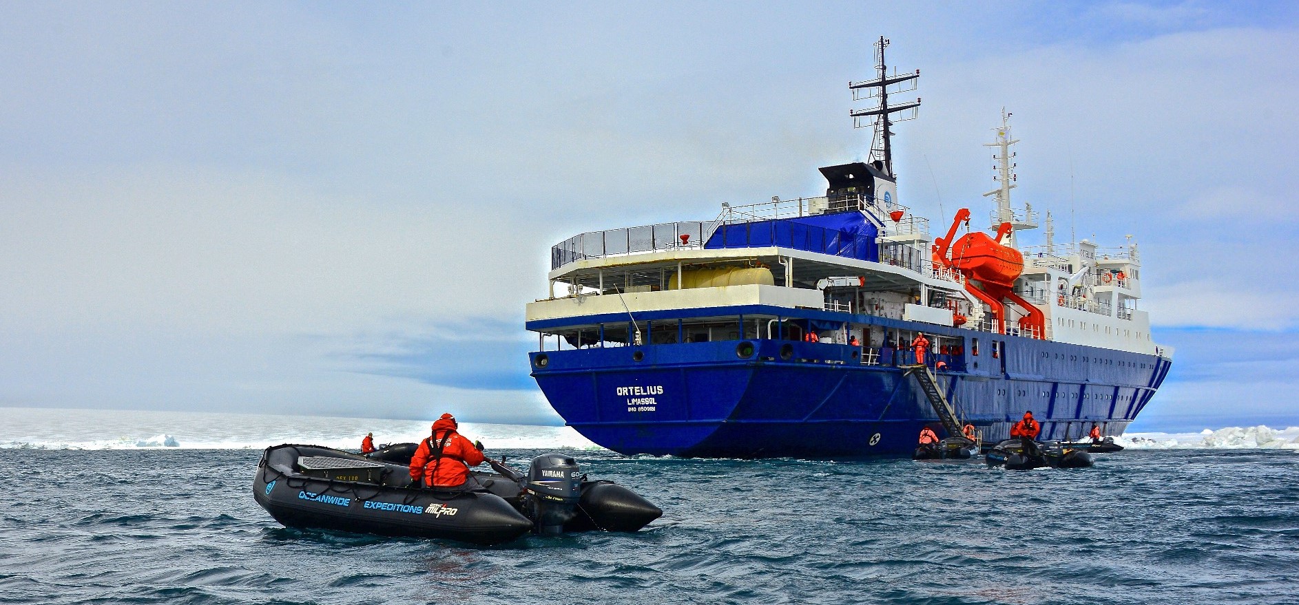
Ortelius
Vessel Type: Expediton
Length: 91m
Passenger Capacity: 108-123
Built / Refurbished : 1989 / 2015
Ortelius was originally the Marina Svetaeva. Built in Gdynia, Poland in 1989, it served as a special-purpose vessel for the Russian Academy of Science. Later it was re-flagged and renamed after the Dutch/Flemish cartographer Abraham Ortelius (1527 – 1598), who in 1570 published the first modern world atlas: Theatrum Orbis Terrarum or Theater of the World. At that time his atlas was the most expensive book ever printed. Ortelius is classed by Lloyd’s Register in London and flies the Dutch flag.
Perfect for Any Expedition
The vessel has the highest ice-class notation (UL1, equivalent to 1A) and is therefore suitable to navigate in solid one-year sea ice as well as loose multi-year pack ice. Ortelius can accommodate up to 108 passengers and has an abundance of open-deck spaces. It is manned by 24 highly experienced nautical crew members, 20 hotel staff, eight expedition specialists (one expedition leader, one assistant, and six lecturer-guides), and one doctor.
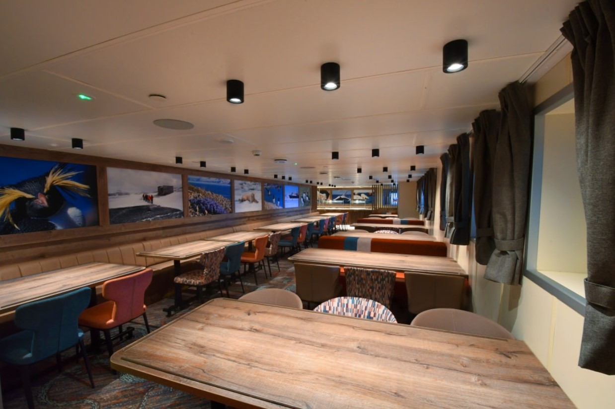
Ortelius: a Vessel with Comfort and Character
Please be aware that a small number of cabins may have a partially obstructed view due to the size of the windows and the design requirements of the ship. For example, some windows may be partly obstructed in the lower half by a gangway. The best view is always on the outer deck or the bridge. Though our voyages are primarily meant to offer our passengers an exploratory wildlife program with as much time ashore as possible, Ortelius offers all the comforts of a standard hotel ― along with a bar and lecture room. Flexibility assures maximum wildlife opportunities. As such, Ortelius carries 10 Zodiacs with 60hp Yamaha engines.
Age & Nationality
Passengers on a typical voyage range from in their 30s to their 80s, with the majority usually between 45 ― 65. Our expeditions attract independent travelers from around the globe who are characterized by a strong interest in exploring remote regions. The camaraderie that develops on board is an important part of the Oceanwide experience, and many passenger groups include several nationalities.
What to Wear
In keeping with the spirit of expedition, dress on board is informal. Bring casual and comfortable clothing for all activities, and keep in mind that much of the scenery can be appreciated from deck ― which can be slippery. Bring sturdy shoes with no-slip soles, and make sure your parka is never far away in case one of our crew shouts “Whales!” over the loudspeaker and you have to dash outside in a moment’s notice. Opt for layers, as it is comfortably warm aboard the ship though often cold on deck.
How to Pay
Refreshments and souvenirs will be charged to your cabin. The day before departure you can settle your bill with the hotel manager, paying by credit card (Visa or MasterCard) or cash (euro, or in some cases dollar). We cannot, however, accept checks. Though the prices and standard currency on board is in the euro, other currencies may be accepted at the discretion of the hotel manager, at prevailing rates.
Electric Current
The electrical supply aboard ship is 220v, 60Hz. Electrical outlets are standard European with two thick round pins, so some passengers may need a 220v/110v converter.
Gratuities
The customary gratuity to the ship’s service personnel is made as a blanket contribution at the end of the voyage and is divided among the crew. Tipping is a personal matter, and the amount you wish to give is at your sole discretion. As a generally accepted guideline, we suggest 8 ― 10 euros per passenger per day. It is better for the crew if you give cash.
Non-Smoking Policy
We have a non-smoking policy inside all our vessels, though you can smoke in certain designated areas. We ask that you please respect the wishes of non-smokers.
Your Physical Condition
You must be in good overall health and be able to walk several hours per day. The expedition is ship-based and physically not very demanding, but we spend as much time as possible on shore. You are, however, welcome to remain aboard the ship if you prefer. To join most excursions you must be able to get up and down the steep gangway ― from the ship to the water level ― to board the Zodiacs. Staff will assist you in and out of the boats, and boarding will become progressively easier with practice, but conditions on shore can be slippery and rocky. Remember, you will be traveling in remote areas without access to sophisticated medical facilities, so you must not join this expedition if you have a life-threatening condition or need daily medical treatment.


• Shore-Based Walking
• Flora & Fauna of South Sandwich Islands
• Emperor Penguins & the Weddell Sea
• Weddell Sea Landscapes
• Prion Island
• Grytviken
• Gold Harbour
• Elephant Island
• Gentoo Penguin
• King Penguin
• Weddell Seal